| Note: The two difficult sections in this walk can be avoided. An easier, although less interesting route to and from Mt Manucoco, would be to walk up from the Anartutu side of the range, on a track that crosses the main range in a saddle 600 meters north of Mt Manucoco. Then turn right and walk south along the ridge to the summit.Anartutu is now accessible by motor vehicle. Four wheel drive (4WD) tracks in East Timor are almost always only used by people or horses. All bearings provided in the trek guides are magnetic, direct from the compass dial.Vila to mountain hutStart in the seaside village of Vila and walk south to a T in the last road.8,16’03.88”S125,36’07.30”E Turn right and go west uphill with Eldai Creek 100 metres away on the left. The track and creek converge. Then walk up past a concrete reservoir. Follow pipes upstream with the creek now on the right, through rain forest. Fifteen minutes after leaving the last house cross a stile; there is then a fence on the left. Just after a gurgling concrete water reservoir on the left, turn off left through a gap in a rock wall, cross over a pipe and walk uphill in vegetable gardens on a spur at 200d, then almost under a corn store up in a tree and onto a 4WD track.Turn left and south. This is the village of Romanua situated on a saddle at an elevation of 300 metres. The temperature here is cooler and more pleasant than down on the coast.From the saddle walk west down the dirt road. Across the valley on the left is Maulako. After going 750 metres turn right over a galvanised steel pipe at a joiner. Scramble up the bank and sidle level into rainforest. Under huge trees there are three water reservoirs. This area is used for washing clothes. Cross a dry creek with the slope away to the left. Sidle along to the crest of the spur with a rocky knoll on the left of the track. Turn off right and follow the track west up a gentle spur, going straight towards the mountains. This leads up through vegetable fields. At a fork in the track ignore the right track and continue straight ahead under a coconut tree and a dead tree overhead. It takes six minutes to get to the next fork.
At a white-trunked gnarled tree, to the right of which is bamboo, take the right fork bearing 300d. Soon you arrive at a T in the track with bamboo straight ahead. Turn right and head north into rain forest. The mountain is now on the left side. After 50 metres the track swings left and zigzags back up into vegetable gardens.
Turn left where there is another bamboo thicket on the right. Zigzag up the spur with a rainforest clad mountain towering over to the north-west. There are great views back out to sea. Climb steeply. At an altitude of about 740 metres the very steep track goes into rainforest and the spur narrows. Continue up into sunlight onto a saddle and a T intersection. Turn right onto the track that leads north. This is the mountain spine of Atauro Island.
After about 100 metres the track turns left and levels. five metres along on the right a faint track is just visible in long grass. Turn right northwards up the open grassed ridge. The level track we turned off goes west to Anartutu.
Our track climbs north into the rain forest. The ridge narrows to a razorback in moist, very slippery black soil with a precipice one meter away to the right. The indistinct track then curves to the right, off the ridge and onto the steep slope. This short section is difficult and dangerous. The track is extremely slippery. You need to work along using hands and feet, holding onto the ferns and roots as you slide one foot along at a time. Most of the ferns will only take part of your weight. The drop below is huge. A couple of the Timorese in our party took their sandals off so that they could get extra traction with their toes along this short dangerous section.
Scramble to the left and back onto the main ridge. Shortly after regaining the ridge, in rainforest after a bamboo thicket, we curved off and gently down to the left into an unmaintained coffee growing area.
If continuing north along the main ridge the route will cross a rainforest mountain top to a saddle immediately south of Manucoco. We rejoined the ridge at this saddle. The coffee plants grow in the shade of a beautiful spreading white trunked acacia, which the Portuguese imported from Brazil. We followed the barely visible formation of an old track down to the west, (fall on the left for about one kilometre) to emerge onto a spur on a grassed terrace and a rough tin roofed hut. There are views west over farm land to Mt Tutonairana.
We spent the night here. Thomas our guide walked down in the direction of a village and returned about an hour later with four litres of muddy water, which we boiled for drinking.
Mountain hut to Manucoco summit
We left the hut at 20d on an overgrown track for the fifteen minute walk back up onto the main ridge. After ten minutes we crossed a slippery, rocky scree slope, falling away left. The track then curves to 60d to meet the ridge and the alternate route in rainforest. Travel north along the narrow ridge and down onto a narrow saddle.

This southern approach to Mt. Manucuco is of great cultural significance. Local folklore says it is dangerous to talk, pick up any objects or think badly of the area as this may cause you to become sick or even die, or the jungle python may change into another animal or person (maybe your friend) and attack you. The track could also disappear. If this happens sit quietly, apologise and pray. Then you may be OK.
Carefully scramble up the rocky razorback exposed ridge to the top of Mt. Manucoco. Nine hundred and ninety five metres high, it is the highest point on Atauro Island. There is a survey marker here, although the jungle clad mountain to the south looks higher and blocks some of the view of the mainland. The views in all other directions are magnificent. The vegetation is very stunted eucalypt and button grass.
Manucoco was once covered in jungle and had no name. At the time a chicken at the top of the mountain made a song, and the people to the north, south, east and west listened to the song and named the mountain. The word Manucoco means Manu (chicken or rooster) Cocu (chicken song or crowing rooster).
Manucoco summit to Illitimur
Scramble north down a rock shelf into rainforest. Continue up and down, along and beside the ridge. After ten minutes you come to a saddle with a distinct cross track. To the right, it heads east down to Romanua, and to the west to Anartutu.
The easiest access to and from Mt Manucoco would be to walk up to this saddle from the Anartutu side of the range, turn right then walk the 600 meters south to the summit.
On the ridge climb north in thick rain forest for approximately 20 metres. Leave the ridge, get onto the east face of the mountain and scramble along the very slippery, very steep slope by holding onto ferns, grasses and roots to work one hand or one foot at a time along this very dangerous section. Extreme concentration is required as most of the handholds are not strong enough to take a person’s full weight. To lose your grip here would probably be fatal.
Climb back onto the ridge and up to the top of the last high mountain. Thick rainforest blocks the view. A little north the track curves left and leaves the rainforest.
Look back from this point and the rainforest-clad mountain south of the open top of Manucoco is clearly the higher of the two. (It may look higher due to the taller vegetation.) There are excellent views north-east of our route to the small grass plains and the northernmost point of this walk, at the narrow end of the island. |

WET KIDS AND FOODSTORE VILLA
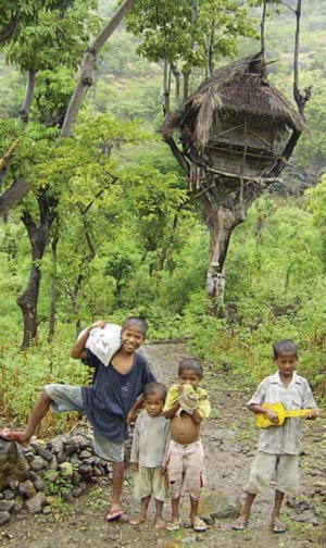
Proceed north along a distinct track down through open sclerophyll eucalypt grassy woodland. The track heads north and to the right of a rocky outcrop. Continue along the undulating path until a track joins on the left. Turn off to the left and sidle along, fairly level at 260d. A palm fence appears on the left the fall is away to the right. Turn left through an opening in the fence. A thatched house is10 metres up to the south. This is Makadardi.
Walk at 190d past houses and over a gentle spur sloping away to the right. Keep to the main track, now amongst lush vegetable gardens and thatch houses. At a Y junction take the right side. Close by, go left. Then climb up a ladder over a two meter high rock fence out of the village and down a rocky gorge. A creek is down on the left. Then climb over a rickety wood fence. No houses here, at a fork in the track. Veer left at 230d. Ten to twenty metres further on at a T, veer left, with houses on left. Fall is on right; go south and right, between tin roofed buildings. Turn right, now at 240d, to meet the main north–south 4WD road in Anartutu. We turned left and down to Thomas’ house near the soccer ground for a great lunch and nap.
On the main dirt road head north uphill out of town with the fall on the left side. About 2.5 kilometres from Anartutu after a sharp left bend there is a foot track falling down on the right. Climb down here into rainforest. In the creek bed is a water collection system, a plant nursery and a rock hole with a dipper to get water from for a shower. Be sure not to contaminate the rock pool. Soap up and wash beside, not in the rock hole.
Walk downstream past elevated water pipe outlets and a paved communal clothes washing area. Continue downstream and turn right, back onto the road where it crosses the creek twice. Then proceed uphill to the village of Illitimur. Just before the village, on a spur above the right side of the road, the NGO Roman Luan intends to build a traditional style guest house.

Illitimur to Vila
At the top of the village the road widens into a netball field. Fifteen metres on turn sharp right and scramble down a well-worn track into a creek valley. Follow the creek down in rainforest and turn sharp right to walk uphill on a road with an embankment on the right. This road winds east gently uphill through farmland to an open grassy saddle on the right side. (The track to the right disappearing over the saddle is the most direct route back south-east to Vila. 2 hours walk away.).
Our track on the road curves left up the gentle slope, the road then goes between two large trees with a stone fence on the left, then sea views on the right. Next is a wooden fence constructed of crooked branches pushed together. The well-worn track goes east through a gap in the fence and down to Beloi. North of this point we saw no people or houses.
Continue north along an overgrown track in the middle of the road, this more or less follows the spine of Atauro. After about three kilometres the road starts to climb and sweep left, with a cutting on the right. There are some scramble marks on the cutting. Climb up here onto an indistinct track heading east to a rock outcrop at the south-east corner of the grass plain, sit and take in the great views of Beloi the offshore reefs, and Indonesian islands.

Walk north-west in long grass. Cross the road on the saddle and continue north-north-west onto another rocky knoll and survey marker at the other side of the plain. There are panoramic views west into a deep ravine, and down to Adara; also north-east to the top of the island, and back to Manucoco. The road continues on north over the saddle. We retrace our steps to the road and follow it back to the crooked wooden fence and the track that goes down to Beloi.
Turn left through the gap in the fence, cross a saddle and small button grass plain the track through goes through eucalypts and drops down to cross a larger grass plain. After passing through a broken stone fence it then curves to the right and onto the side of a ravine with the drop on the left. It then follows a steep spur down to a hamlet and the confluence of two creeks.
From here simply follow the creek bed down stream to the coast road. Turn right for the four kilometre walk back to Vila, or left for the few hundred meters to Beloi.

The above trek is of medium to hard difficulty. If you approach the ten-minute ridge walk to Mt Manucoco via the track from the Anartutu side of the range, the trek is only of medium difficulty as this avoids the two dangerous sections.
In these mountains beautiful sunny conditions can quickly turn into heavy fog. You can rapidly become lost and get into serious trouble. This is one of the main reasons why it is so important to have a guide.
Note: this trek guide was written in Australia from notes taken during a trip in May 2004. It should be taken as an indication only and common sense should be used at all times. The author welcomes any corrections to update this information. |