MATEBEAN MOUNTAINS
| The region The alpine type Matabean mountains are probably the most rugged in Timor. Although lower than those in the Ramelau area, here you have a longer climb to get to the 2377 meter summit of Matebean Mane, the largest and southernmost of the two Matebean Mountains. The town of Baguia is only 400 meters above sea level.From Baguia you walk to the 1200 meter high mountain village of Uaiboro, nestled under the east cliffs of Matabean Mane. Then there is still a hard climb to the 2377 meter, very rocky and exposed summit of this mountain.The two treks could be done as a 3-day walk, or three separate 1-day walks with overnight stays in Uaiboro.
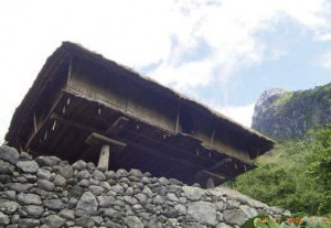
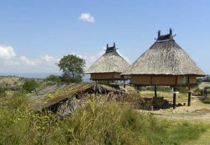
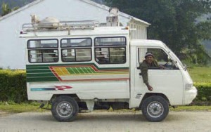
UAIBORO MT. MATEBEAN The people in the Baguia area are Macasae and Nauoti and most speak Macasae and Indonesian. A minority speaks Tetum and Portuguese, very few speak English. This community still has a traditional system, with local chiefs and very strong family commitments. On the road to Baguia you will notice traditional elevated thatched houses. There is no trafficable road to the south coast. However a two day walk or a day on a cycle will get you to the Timor Sea (Tasi Mane). Access Buses and trucks to Baguia leave most days from above the upper market area of Bucau. The trip by 4WD takes three to four hours, in express mini bus four hours; the local three-ton trucks carry passengers and take about five hours due to many stops and the difficulty getting through damaged sections of the roadway. On the north coast road 18 kilometers east of Baucau is the village of Laga. (Baguia is 43 kilometers by road to the south.) Travel to the east end of Laga. 8,29’040.98”S 126,33’59.00”E Just before the Lospalos Road drops down to the left off the plateau there is a turn off to the right. This broken road curves around fairly level to the right and heads south-east up through dry farmland, past two new traditional elevated thatched houses on the right. These overlook the Le Quinamo River 700 meters away down on the right hand side. At the top of each of these traditional houses is Lulic, a secret area. The carved birds sitting at each end will bring the spirits through to this loft area called Gau where sacred objects are kept. This keeps the residents safe in the main part of the house. Only the head of the family is allowed into this top area. The building is supported on poles that are fitted with discs to prevent entry. The only access is via the front door up a removable ladder. |
The road then drops down into the Laivai watershed with the river on the left hand side.
At the border between Laga and Baguia districts at a place called Ulilatta is a bridge over the Gomilafa River. Looking upstream through the rainforest the remains of an old stone bridge are visible with a 10 meter waterfall further upstream. This is a special area. After the rice harvest the local people bring a buffalo here and slaughter it. Then they feed the heart to the eel in the river. Prior to this the people are not allowed to swim here or they may come to harm. After feeding the eel it is OK to swim and this feeding also guarantees good rains and harvest for the next season. The road then climbs up to cross into the southern watershed at an elevation of 460 meters, and into a wet fertile area with many terraced rice paddies. At Hiberi (38 kilometers from Laga) above the road on the right is the massive ruin of an old Portuguese school. This was destroyed in the 1940s. Baguia: organising your trek Once you have entered Baguia, at a right turn in the road is another large Portuguese restored ruin complete with battlements and dungeons. This was the district administration centre, where in 1959 the last uprising against the Portuguese colonizers took place with bloody reprisals against the Timorese. The main street runs east west facing straight up towards the high plains and Matebean Feto, the northern and smallest of the two Mount Matebeans.(In Tetun feto=woman mane=man) Martino and Adelaide at the Rabalai guesthouse on the right at the top of the hill +67077376137 should be able to provide meals and accomodation, there is a kiosk opposite. Martino should also be able to arrange a guide and also accomodation at Uaiboro or possibly a family stay. They speak Tetun ,Indonesion, Portuguese and some English. Power lines have been installed to Baguia ,this has allow the installation of a phone tower for the operation of mobile phones in the area. As of 2014 the mobile phone reception is good in most areas of Timor. Baguia is on an east-west ridge at an elevation of 400 meters. The sub-district of Baguia is 207 square kilometers and has a population of approximately 11,000: mostly Catholic farmers whose produce is consumed locally due to the high cost of transport to other markets. At present it is eaisest to contact Carlito Alves or Pedro Lebre in Dili to orginise your visit. (See contacts) The locals are keen for travelers to visit the area. Possible treks:
|


